Компания Avenza Systems, разработчик системы подготовки ГИС карт к изданию (MAPublisher) в среде Adobe Illustrator and Macromedia FreeHand, а также баз данных MAPdataUSA и MAPdataWorld, объявила о выпуске расширения Geographic Imager, которое призвано дополнить эту мощную графическую систему возможностями работы с геопространственными данными. Новое расширение содержит новые инструментальные средства для поддержки импорта/экспорта ГИС-данных, аэрокосмических снимков и их редактирования, что позволит полностью использовать все функциональные возможности Photoshop для работы с графикой. С помощью Geographic Imager в среде Adobe Photoshop станут доступны операции с geotiffs и другими форматами географически привязанных изображений, автоматическое составление мозаик, преобразования в другие проекции на основе опорных точек. Transform
Extensive support for thousands of geographic and projected coordinate systems. Easily transform between geodetic and projected coordinate systems. Need to define your own coordinate system? Create one or edit an existing definition and save it for future use. Manage custom transformations in an easy to use coordinate system browser. Georeference
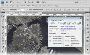
Georeference images easily by adding ground control points. Manually add control points, import or export points from a text file, and view accuracy and errors. Use the Quick Georeference option to make georeferencing even easier. Multiple transformation types are supported. Mosaic
Snapping images together not working? Mosaic individual images to create a seamless image. Retain images as separate layers or flatten to create one image. Images mosaicked together retain spatial referencing and can be individually modified using Adobe Photoshop tools or transformed using Geographic Imager. Tile
Forget the Slice tool. Tile an image into multiple images by tile size or count and automatically save them using sequential naming. Tiles retain spatial referencing making it ideal to import into MAPublisher without any trouble. What's new in Geographic Imager 3.0.1?
GeoCrop Import: added support for 12-bit JPEG compressed GeoTIFF / TIFF (common Intergraph output format)
Improved import of various geospatial raster formats such as GeoTIFF and NITF
Eliminated editing delays when handling long modification history for large images
Various minor bug fixes and optimizations Geographic Imager 3.0 features and additions
64-bit support - Geographic Imager is now supported on Adobe Photoshop CS4 64-bit for Windows XP/Vista/7. Open larger images and greatly improve Adobe Photoshop and Geographic Imager performance.
New supported image formats - Several new formats are supported: BIL, NITF and BigTIFF. See all Geographic Imager supported formats.
Georeference - Several enhancements were made to the Georeference tool. The ground control points can now be specified in their own coordinate system within the Georeference dialog box. The Quick Georeference functions has an additional option to load the reference of another file. New customizing options have been introduced such as control point and label colours. A tool to remove georeference has been added
GeoCrop - New and improved GeoCrop and GeoCrop Import user interface. It now includes a crop image preview. Draw a crop marquee, use point proximity or specify pixel, geodetic or projected coordinates or to define a crop area quickly and easily.
Digital Elevation Model (DEM) Schema - DEMs provide an effective method of storing information for a continuous surface. DEM data needs to be rendered, so it can be displayed visually. Depending on what type of DEM data it is and how it should look, the type of rendering schema needs to be customized or automatically assigned.
Tiled images can now be saved to any image formats supported by Adobe Photoshop
Automating tasks - All functions provided by Geographic Imager are now fully compatible with scripts and actions, and can be scripted or recorded to easily automate repetitive tasks.
Licence management - New licensing management system. Easily manage license options including commercial, academic, multi-user and floating.
Various other user interface improvements and performance enhancements to improve usability. Официальный сайт | Home Page www.avenza.com
Размер: ~ 125 MB
Avenza.Geographic.Imager.v3.1.for.Photoshop.HAPPY.8th.BDAY-RECOiL
|